- Home
- About Us
- Contact Us
- News
- Planning Matters
- Environment Matters
- About Portmarnock
- Gallery
- Useful Links
- News Archive
- Portmarnock Tidy Towns
- Monthly News Updates
- Support Portmarnock Local Business
- FORUM
- Geology Walk Portmarnock
- Geology across the Rocks
- PCA Blog
- Portmarnock Sustainable Energy Community
About Portmarnock
The following is a summarised history of Portmarnock written by local historian Garry Ahern. Garry has recently published 'Portmarnock Its People And Townlands'. The book can be purchased at Mace ('Texaco'), Centrepoint shops in the village, and at Spar (at the seafront).
The earliest local residents were late-Neolithic (4,000 - 2,000 BC) or early-Bronze Age (2,400 - 600 BC) people who settled in the Robswall area. They manufactured arrowheads, axe-heads and hammerheads in the Paddy’s Hill area. The belief is that Saint Patrick came this way in the fifth century, hence the naming of the hill and a well there, after him. In Grange, to the west, ring-forts date from approximately 2,000 years ago.
Saint Marnock, who arrived in the 6th century, established his church on the dunes. The entire parish area was eventually named after him (‘Port Mearnóg’ / The Landing Place of Marnock) He may thus be regarded as the founder of the distinct entity which evolved as Portmarnock.
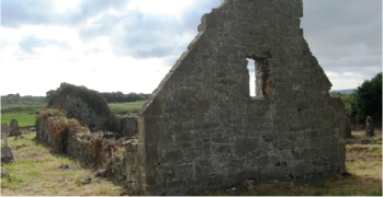
Saint Marnock’s Church
The stone church on the dunes, off Strand Rd., now in ruins, dates from the twelfth, or possibly the early thirteenth, century. It is believed to have been preceded there by at least one earlier church, probably built of wood. The church had triple bell-arches, arranged ‘one-above-two’.
St Marnock’s Well
The site of the holy well, once accessed by sixteen steps leading down, lies near Saint Marnock’s churchyard. The well (now covered over)was for many centuries a place of pilgrimage, notably by members of the Talbot family of Malahide Castle. An annual pattern-day, which included devotional practices, continued there until possibly the early 19th century.
Protected Monuments
St Marnock’s Church and churchyard burial-ground, the Ogham Stone, and St Marnock’s Well, are all included in Fingal County Council’s list of protected monuments and in the National Monuments Service’s list of monuments.
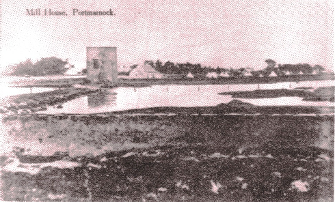
Portmarnock Tide-Mill
From the 12th century, the Abbey of St Mary, Dublin, had watermills at its various land-holdings in Co. Dublin, including Portmarnock.-After the dissolution of the monasteries in the 16th century, the Barnewall family of Turvey gained the lands of Burrow and the tide-mill there. Subsequently the mill was let to a number of different operators, before eventually falling into disuse in the 19th century. Its stone-work of remains visible near the bridge on Strand Rd.
Medieval Times
In the early ninth century the Norsemen arrived and it may have been they who built the original tide-mill. The last Danish King of Dublin, Hamund Mac Turcaill, held lands in Portmarnock until the late 12th century, when the Anglo-Normans ousted him. Members of the Talbot family then had a motte and bailey base constructed at Wheatfield. Later, they built Malahide Castle and moved there. The surviving earthen motte and bailey mound at Wheatfield remains and is a protected monument. The Normans had introduced rabbits to Ireland and a commercial rabbit warren was operated in Burrow over ensuing centuries.
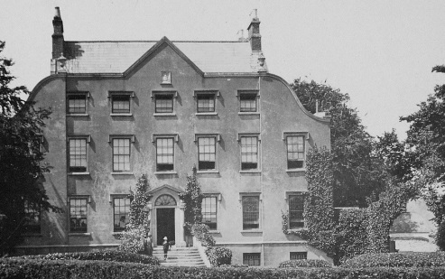
In 1174, Portmarnock was granted to Saint Mary’s Abbey, Dublin, by royal charter. This was to bring about the monastic ‘Grange of Portmarnock’, comprising the western portion of the parish. In the 15th century, a village was established in an area straddling the present Station Road and this existed until the late 17th century. The abbey held Portmarnock until the dissolution of the monasteries in the 16th century. Subsequently, Portmarnock was divided between members of the Barnewall family (Robswall and Burrow) and the Plunkett family (Grange/Carrickhill/ Portmarnock.) In the 17th century, Walter Plunkett had his Grange lands confiscated for siding with the 1641 rebellion. Those lands were eventually, subdivided into the modern townlands of Grange, Hazlebrook, Broomfield, Saint Helens and Beechwood. The Plunketts in Portmarnock House, however, managed to retain their lands, which they held until the mid-20th century.
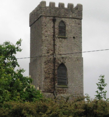
Some Historic Projects
In the 19th century, much of the built environment of Portmarnock, some of which has not survived, was constructed. Projects included the ‘New Road’ (now Station Rd.), the Dublin and Drogheda Railway (1844), John Jameson’s residence, ‘St. Marnock’s’ -1847-, along with its estate (and its later North and South Lodges), two Martello Towers (at Carrickhill & Robswall, 1804-6), a Coastguard Station at Robswall (1885-between High Rock & Monk’s Meadow), Portmarnock National School (1868) and Portmarnock Golf Club (1894). Principal local landowners’ residences then included Portmarnock House (Plunketts) , Beechwood House (Trumbulls), Carrickhill (Willans), ‘St. Marnock’s’ (Jamesons), Grange House, Hazlebrook House, Broomfield House, and Wheatfield. The latter, for long now held by the McDowell family, is the only such house now continuing in use as a private residence while the Jameson’s ‘St. Marnock’s’ has been a hotel for many decades. (The other houses mentioned have either been demolished or are in ruins).
Portmarnock Parish Area
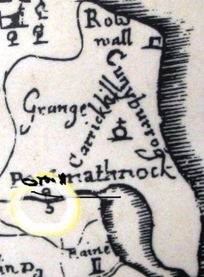
Since the mid-20th century, different factors have possibly tended towards altered perceptions of Portmarnock parish area. Those factors include changed postal addressing, revised church parish areas and new housing developments around the edges. In the 19th century, the Ordnance Survey set out the boundaries of the Civil Parish and its ten internal townland divisions, on which subsequent local taxation and electoral arrangements were based. These townlands are Beechwood (Coill na bhFeánna), Broomfield (Gort na Giolca), Burrow (An Coinicéar), Carrickhill (Cnoc na Carraige),Glebe (Gléib), Grange (An Ghráinseach), Hazlebrook (Sruthán an Choill), Portmarnock (Port Mearnóg), Robswall (Ballaí Robac) and Saint Helens (Teach San Eiléan).
'Old Portmarnock' and Modern Portmarnock
Growth of the modern village followed developments in the 20th century such as opening of the coast road to Malahide, the establishment of a Post Office and a Catholic church (the ‘Tin Church’) on Strand Rd., growth in the number of day-trippers and, particularly, new housing. Until then, much of the focus of local activity had been in the area now known as ‘Old Portmarnock’, an area where the medieval village had existed until the late 17th century. By the early years of the 20th century there was the new (C.I.) St. Marnock’s church there, along with Portmarnock House and estate, a flourishing Plunkett brickworks, a railway station, a blacksmith’s forge and eventually, for a time, a post-office, all within a radius of a half-a-mile or so. The total parish population then was no more than 500.
Over time, the balance shifted eastward, especially so when Saint Anne’s Estate was built in the 1950s and the modern village evolved. During the late 1960s and early 1970s, the rate of increase in population accelerated. Other new housing estates were built, first in Carrickhill, then at Martello, the Dunes and elsewhere. New schools and churches, along with Portmarnock Sports and Leisure Centre, were established to cater for a fast-growing and young population, which by the turn of the 21st century had grown to over 8000.
Historic Flights
The sculpture Eccentric Orbit (Rachel Joynt and Remco de Fouw- erected 2002.) at the seafront is of limestone, bronze and stainless steel. The needle points to the North Star, an age-old navigation point. The sculpture commemorates the epic flights of the ‘Southern Cross’ (1930-second ever non-stop east-west North Atlantic flight), the ‘Heart’s Content’ (1932-first ever east-west non-stop solo North Atlantic flight) and the abandoned solo flight North-Atlantic of ‘Faith in Australia’ (1933).
